If you're here, you probably know a thing or two about A Confederacy of Dunces and Ignatius J. Reilly. If you don't, please stay, read a bit, and then pick up the book.
A Confederacy of Dunces was written by John Kennedy Toole in the mid- and late-1960's and he committed suicide in 1969, before the book was published. Its tragic that we lost such a talented writer before his genius was even recognized. His mother took the manuscript to Walker Percy, a professor at Loyola University, and asked him for his help in getting it published. Percy had seen plenty of unpublished manuscripts and was frankly skeptical that this one would be any better than the stack of underwhelming novels he had already seen. What Percy found was that the deeper he read, the more he liked it. Percy helped Toole's mother get it published and Confederacy went on to win the Pulitzer Prize for fiction in 1980.
Confederacy is set in New Orleans and is written in such a way that the city itself becomes one of the characters in it. I have yet to read a book that captures the spirit of New Orleans as fully. Midnight in the Garden of Good and Evil did a magnificant job of capturing Savannah, but not even Anne Rice is up to Toole's mettle.
The title of the book comes from a line in an epigraph by Jonathan Swift: "When a true genius appears in the world, you may know him by this sign, that the dunces are all in confederacy against him." The main character of Confederacy is Ignatius J. Reilly who truly believes that dunces everywhere are in confederacy against him.
I've gone through Confederacy and noted every location in which Toole mentions. In August 2008, I visited New Orleans and chronicled every location I could find. Where applicable, I tried to give you a little history of the sites, as well as a couple photos. I think I've found every place he mentioned, but if you think I've missed one, please let me know.
Also, I think I've nailed down the exact time in which the book was set.
Read on and take a tour of A Confederacy of Dunces...
Friday, January 2, 2009
Thursday, January 1, 2009
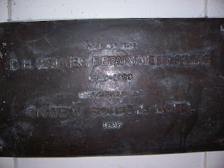
D.H. Holmes Department Store
D.H. Holmes Department Store
As A Confederacy of Dunces opens, Ignatius is waiting for his mother outside the D.H. Holmes Department Store in the 800 block of Canal Street. Irene Reilly had driven her only son to the French Quarter and left him to his own devices while she went to the doctor to tend to a painful elbow. Now, as the sun was setting, Patrolman Mancuso spotted a suspicious character and was carefully watching him from behind a nearby pillar.
The D.H. Holmes Department Store was a landmark in New Orleans and “under the D.H. Holmes clock” was a popular place to meet. The building where the store once flourished is now a hotel, called the Chateau Sonesta Hotel which opened in 1995. The D.H. Holmes Department Store opened on Canal Street in 1849 and closed in 1989. It closed after the chain was purchased by Dillard’s the same year.
This is the building…

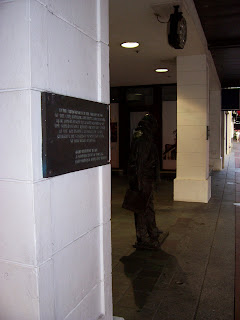
As New Orleans is prone to do, she honored her native son, Ignatius, by placing a statute of him under the clock. She also placed a plaque on the pillar behind which Patrolman Mancuso was hiding.
Here are a couple of photos showing the statute of Ignatius…

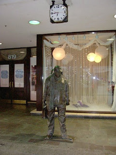


Here are a couple of photos showing the statute of Ignatius…
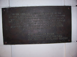
Here’s a shot of the pillar, and Ignatius, and then a close-up of the plaque…
The text of the plaque is one of the first lines of the book and describes Ignatius…
“In the shadow under the green visor of the cap Ignatius J. Reilly’s supercilious blue and yellow eyes looked down upon the other people waiting under the clock at the D.H. Holmes department store, studying the crowd of people for signs of bad taste in dress.
John Kennedy Toole”
Toole says that Ignatius killed some time while waiting for his mother. He bought some sheet music for his trumpet and a string for his lute at Werlein’s. In 1853 Phillip P. Werlein moved his music business to New Orleans and set up shop on Canal St. The business flourished and locations were opened across the country. The business was family owned until the company was bought out in 1940. The Werlein family continued to run the New Orleans shop on Canal Street and they still own the building, although the music shop is no longer there. They moved their music business to a much larger, more modern building in Metairie in 1989. The original Werlein building now houses a very successful restaurant and the Werlein Music sign still sits atop the roof. It survived Hurricane Katrina and is a beacon of neon in the French Quarter…
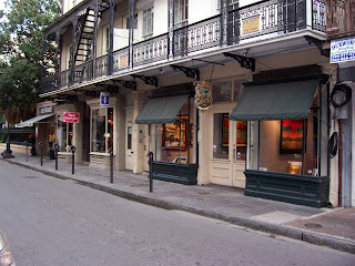
After purchasing the sheet music, Ignatius then wandered into a penny arcade on Royal Street and was disappointed to find his favorite mechanical baseball game absent. I’ve walked up and down Royal and found no sign of a penny arcade, or any other sort of arcade, for that matter. Today, Royal Street is known for its antique stores, jewelers, and art galleries. Most of the stores are small and a penny arcade would fit in quite well.
Here’s a couple of photos of Royal Street…
Here’s a couple of photos of Royal Street…
Night of Joy -- Police Station
The Night of Joy Bar
After Mrs. Reilly and Ignatius escape Patrolman Mancuso at the D.H. Holmes Department Store, they went down Bourbon Street and into the French Quarter. They duck into a bar to grab a drink and get off the street. The bar they chose is called The Night of Joy and it has nude dancing girls there at night.
Ignatius tries to order a Dr. Nut, but ends up with a beer. Mrs. Reilly orders a beer and then ends up drinking several. Ignatius entertains his mother and the bartender with his riveting tale of the Scenicruiser trip to Baton Rouge while Mrs. Reilly drinks away.
They end up meeting Dorian Greene and he buys Mrs. Reilly’s hat for fifteen dollars.
The bar is described as dark and smelling of bourbon and cigarette butts. There are a number of strip clubs up and down Bourbon Street, but most of them are not as dark and dank as the Night of Joy. Most of them have a lot of chrome and mirrors and don’t seem to be anything like Lana Lee’s joint. The current trend in strip clubs is to make them “Gentlemen’s Clubs,” that have nice décor and don’t look seedy at all.
Here’s a shot of Bourbon Street. On the left, you can see a couple of entertaining ladies who are trying to drum up business by standing outside and persuading customers to enter…

This bar isn’t on Bourbon Street and its not a strip club, but it looks kind of like what I imagine the Night of Joy to look like…
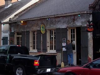
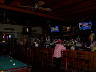

I know there’s no stage in this bar and I know there were no pool tables in the Night of Joy, but I still think this one has the right “feel.”
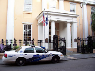
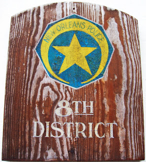
The French Quarter Police Station
After Claude Robichaux was arrested by Patrolman Mancuso, he was taken to the French Quarter Police Station and handcuffed to the bench near the Sergeant’s desk next to Burma Jones.
The French Quarter Police Station is run, of course, by the New Orleans Police Department, which is one of North America’s oldest police agencies. It was formed in 1718 when New Orleans was still in French hands.
The building which now houses the New Orleans Police Department’s 8th District Police Station was built in 1826 and was originally the Bank of Louisiana.
Here’s a shot of the building’s exterior, and a shot of the plaque just outside the door…
Here’s a shot of the interior, and of the Sergeant’s Desk…

The bench is just behind the desk, under the folded, framed American flag. I would’ve got a couple photos of the bench, but there was someone already in it…Handcuffed, just like poor old Claude Robichaux.
6/21/2010 edit: lkme55, my version of the Night of Joy bar is Molly's on Toulouse St., which you can find at 732 Toulouse St. It's about 25 yards south of Bourbon St. I hadn't really noticed when I took those photos, but you're right...That patron looks just like a Lucky Dog vendor. Perhaps he's taking a break and cooling his heels like his hero, Ignatius.
After Mrs. Reilly and Ignatius escape Patrolman Mancuso at the D.H. Holmes Department Store, they went down Bourbon Street and into the French Quarter. They duck into a bar to grab a drink and get off the street. The bar they chose is called The Night of Joy and it has nude dancing girls there at night.
Ignatius tries to order a Dr. Nut, but ends up with a beer. Mrs. Reilly orders a beer and then ends up drinking several. Ignatius entertains his mother and the bartender with his riveting tale of the Scenicruiser trip to Baton Rouge while Mrs. Reilly drinks away.
They end up meeting Dorian Greene and he buys Mrs. Reilly’s hat for fifteen dollars.
The bar is described as dark and smelling of bourbon and cigarette butts. There are a number of strip clubs up and down Bourbon Street, but most of them are not as dark and dank as the Night of Joy. Most of them have a lot of chrome and mirrors and don’t seem to be anything like Lana Lee’s joint. The current trend in strip clubs is to make them “Gentlemen’s Clubs,” that have nice décor and don’t look seedy at all.
Here’s a shot of Bourbon Street. On the left, you can see a couple of entertaining ladies who are trying to drum up business by standing outside and persuading customers to enter…
This bar isn’t on Bourbon Street and its not a strip club, but it looks kind of like what I imagine the Night of Joy to look like…
I know there’s no stage in this bar and I know there were no pool tables in the Night of Joy, but I still think this one has the right “feel.”
The French Quarter Police Station
After Claude Robichaux was arrested by Patrolman Mancuso, he was taken to the French Quarter Police Station and handcuffed to the bench near the Sergeant’s desk next to Burma Jones.
The French Quarter Police Station is run, of course, by the New Orleans Police Department, which is one of North America’s oldest police agencies. It was formed in 1718 when New Orleans was still in French hands.
The building which now houses the New Orleans Police Department’s 8th District Police Station was built in 1826 and was originally the Bank of Louisiana.
Here’s a shot of the building’s exterior, and a shot of the plaque just outside the door…
Here’s a shot of the interior, and of the Sergeant’s Desk…
The bench is just behind the desk, under the folded, framed American flag. I would’ve got a couple photos of the bench, but there was someone already in it…Handcuffed, just like poor old Claude Robichaux.
6/21/2010 edit: lkme55, my version of the Night of Joy bar is Molly's on Toulouse St., which you can find at 732 Toulouse St. It's about 25 yards south of Bourbon St. I hadn't really noticed when I took those photos, but you're right...That patron looks just like a Lucky Dog vendor. Perhaps he's taking a break and cooling his heels like his hero, Ignatius.
Bourbon St. -- St. Ann
Bourbon St./St. Ann St.
When Ignatius and Ms. Reilly left the Night of Joy, they walked to her car, which was parked on St. Ann St., just off Bourbon St.
When Ignatius and Ms. Reilly left the Night of Joy, they walked to her car, which was parked on St. Ann St., just off Bourbon St.

Mrs. Reilly had a difficult time extracting the 1946 Plymouth from the parallel parking space and hit a Volkswagen that was parked behind them. She also “climbed the curb twice” during her efforts, and Ignatius was of course no help as he complained endlessly from the back seat.
Finally, the car “leaped out of the parking spot and skidded across the wet street into a post supporting a wrought-iron balcony.” Toole described Mrs. Reilly and Ignatius hearing the “splintering of wood” as the balcony fell on the roof of the car.
Here’s a photo of the corner…
Finally, the car “leaped out of the parking spot and skidded across the wet street into a post supporting a wrought-iron balcony.” Toole described Mrs. Reilly and Ignatius hearing the “splintering of wood” as the balcony fell on the roof of the car.
Here’s a photo of the corner…

Notice the balconies on the left? The support posts that are painted white are the only wooden ones on the block. All the others are wrought-iron. It was probably those posts that Mrs. Reilly splintered.
In addition, parallel parking is on the right-hand side of the road. If Mrs. Reilly was going to skid across the street and hit the post, that would be the perfect place to do it.
Here’s a closer shot of the posts…
In addition, parallel parking is on the right-hand side of the road. If Mrs. Reilly was going to skid across the street and hit the post, that would be the perfect place to do it.
Here’s a closer shot of the posts…

Just as Mrs. Reilly was smashing the posts, Patrolman Mancuso was walking down Chartres. He turned the corner, looked up St. Ann and saw “the green hunting cap emitting vomit among the ruins.”
Here’s a shot on St. Ann looking towards Chartres. It’s the next intersection…
Here’s a shot on St. Ann looking towards Chartres. It’s the next intersection…

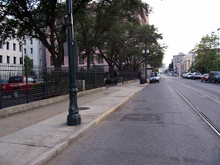
St. Charles Avenue
St. Charles Ave.
After Mrs. Reilly knocked over the balcony on St. Ann St., Patrolman Mancuso went to her house to talk with her about the situation. While driving there, he admired “the ancient oaks of St. Charles Avenue” as they “arched over the avenue like a canopy shielding him from the mild winter sun that splashed and sparkled on the chrome of [his] motorcycle.” Toole’s description of St. Charles Avenue hasn’t changed much since Confederacy was written, and the magnificent trees still provide ample shade to this day.
Here is a photo of some of them, but it really doesn’t do the trees full justice. They are beautiful…
The Reilly House
The Reilly House
Toole was pretty specific when he talked about where the Reilly house was located. He says that when Patrolman Mancuso reached Constantinople St., “he turned toward the river,” which is to the south. The house was “the tiniest structure on the block” and a “frozen banana tree, brown and stricken, languished against the front porch, the tree preparing to collapse as the iron fence had done long ago.” Toole also said, “near the dead tree there was a slight mound of earth and a leaning Celtic cross cut from plywood.” This was the resting place of Ignatius’ beloved dog, Rex.
Patrolman Mancuso found that the Plymouth was “parked in the front yard” and “its taillights blocking the brick sidewalk.”
This places the Reilly House squarely in the Touro neighborhood, which is a sub-district of the Uptown Area of New Orleans. Over the years, this neighborhood has changed a great deal. It was once a relatively poor area, with depressed home values and a working-class flavor. Today, gentrification has changed the face of the neighborhood and most of the houses have been heavily renovated. While most of this area of New Orleans was spared by the flooding that followed Hurricane Katrina, there was significant damage. Most structures sustained at least some damage from the high winds. Even now, construction dumpsters can be seen on almost every street.
I’ve gone up and down Constantinople St., looking at “tiny structures” and I think I may have found the best candidate for the Reilly House.
Here we have a house that is the tiniest on the block, with an iron fence, and a small front yard. Of course, there is no dying banana tree, but there is a front porch. Speaking of the front porch, Patrolman Mancuso “climbed the worn brick steps” to get to the front door. Last, but not least, notice that there’s a brick sidewalk out front. If you were to park a 1946 Plymouth in the yard, its taillights could block the sidewalk. Take a look…

Toole mentioned an alley that was next to the house, but there doesn’t appear to be one at this house. Of course, alleys are sometimes closed up and annexed by the adjacent property owners and that may have happened in this case. I wasn’t able to find a small house sitting directly next to an alley.
But there is a house with a second story right next door where Ms. Annie could yell down to Ignatius to be quiet…
But there is a house with a second story right next door where Ms. Annie could yell down to Ignatius to be quiet…

Here’s another good candidate for the Reilly House, but there’s no brick sidewalk…

Here are a couple of good looking smaller houses, but they appear to be about the same size. The Reilly House was the tiniest on the block.

Here are a couple more. Note the construction dumpsters…

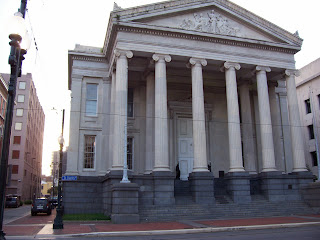
Hibernia Bank
Hibernia Bank
While lamenting to Ignatius about the destroyed balcony, Mrs. Reilly mentions that she has $150 at the Hibernia Bank. The Hibernia National Bank was founded in 1870 and was headquartered in New Orleans. It became very successful and was the primary bank for most of Louisiana for a long time. It was acquired by Capital One in 2005.
Their headquarters building still sits at 812 Gravier St. in the Central Business District.
Here’s a photo of the headquarters building…
In Carrollton, I found this bank, which is the Hibernia Homestead Bank. I imagine Mrs. Reilly would have conducted her meager business in a bank like this one…
Tulane University
Tulane University
Ignatius went to Tulane University and then “stuck around there for four more years to get him a master’s degree.” Mrs. Reilly is very proud to tell people that her son “graduated smart.”
Tulane University was founded in 1834 as a medical school. It expanded and its current campus opened in 1894. The campus sits on St. Charles Avenue and is flanked by many beautiful, and huge live oaks.
Here’s a photo of the main building…
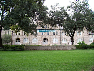
Ignatius loves to tell the story of how he took a Scenicruiser bus to Baton Rouge to take a job in the “Medieval Culture Department” at an un-named university. There are a number of small colleges in and around Baton Rouge, but Toole was probably referencing Louisiana State University.
Prytania
Prytania
Ignatius was apparently a frequent customer of the Prytania movie house, because the staff talks derisively of him being there “again.” The Prytania is a wonderful example of how theaters once looked. They were elegant and cozy and two screens were more than enough for the neighborhood.
The Prytania opened in 1915 as a single-screen theater and today it is the only one in Louisiana. It recently underwent a major renovation that added a new lobby and a huge screen.
Here’s the Prytania’s website with a couple of old photos, showing how it probably looked when Ignatius critiqued their films.
http://www.theprytania.com/
The Prytania is still open at 5339 Prytania St. and its not far from the Reilly House on Constantinople St.
Here are a couple of photos of the exterior as it looked in August 2008…


Here are a few photos of the interior. In the first picture, you can see the counter where Ignatius would have purchased his Milky Way bars, popcorn, and soda…
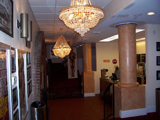

When I was there, they were showing “Tropic Thunder”…

In Toole’s description of the movie Ignatius watched and hated, we can get an idea of the time in which the book was set. Its pretty obvious that it was set in the early 1960’s, but by looking at several clues we can narrow it down even further. For example, the movie was a musical which was set in a circus. There were trapeze acts, a sideshow, and an elephant. The movie was distributed by MGM, because Ignatius listened as “the lion roared,” just before the title screen.
That all perfectly describes “Billy Rose’s Jumbo,” which starred Doris Day and Jimmy Durante. It was released in the United States on December 6, 1962. This matches up with other references in the book that I’ll discuss as we get to them. The winter release also matches up with Toole’s passage concerning Patrolman Mancuso riding the motorcycle on St. Charles Avenue through the “mild winter sun.”
I think its fair to say that A Confederacy of Dunces was set in the winter of 1962 - 1963.
Levy Pants, Inc.
Levy Pants
At his mother’s insistence, Ignatius answered a classified ad in the newspaper and began working for Levy Pants, Inc. The ad told prospective employees to “Apply Levy Pants, Industrial Canal and River,” which places the building at the eastern border of the Bywater neighborhood.
Bywater is part of the Ninth Ward, and more specifically, the Upper Ninth Ward. The Upper Ninth Ward is “upriver” from the Lower Ninth Ward and both sit just east of the French Quarter.
Here’s a Google Map’s view of Bywater, and coincidentally, the “stick-pin” is probably pretty close to where Levy Pants would have been…
http://maps.google.com/maps?hl=en&q=bywater%2C%20new%20orleans&um=1&ie=UTF-8&sa=N&tab=wl
Ignatius entered and took in the building, and Toole describes it as such:
“Through the dusty windows of the office there was a gray view of the Poland Avenue wharf, the Army Terminal, the Mississippi, and, far in the distance, the dry docks and the roofs of Algiers across the river.” From this vantage point, Ignatius is looking towards the southeast.
Later, as Ignatius heads home, the taxi takes St. Claude Ave., which is one of the main roads through that part of New Orleans. It roughly parallels the River and would easily take him back to his own neighborhood and Constantinople St.
Toole described the building in more detail in another passage:
“Levy Pants was two structures fused into one macabre unit. The front of the plant was a brick commercial building of the nineteenth century with a mansard roof that bulged out into several rococo dormer windows, the panes of which were mostly cracked. Within this section the office occupied the third floor, a storage area the second, and refuse the first. Attached to this building, which Mr. Gonzalez referred to as ‘the brain center,’ was the factory, a barnlike prototype of an airplane hangar. The two smokestacks that rose from the factory’s tin roof leaned apart at an angle that formed an outsized rabbit-eared television antenna…”
He went on to say:
“Alongside the neat gray wharf sheds that lined the river and canal across the railroad tracks, Levy Pants huddled, a silent and smoky plea for urban renewal.”
Those are all very descriptive and clearly place the building in Bywater, near the river, and near the Industrial Canal. I’ve been all through this area and I cannot find a building that looks like the one Toole is describing.
Most of the wharfs are gone, but its easy to tell where they once were. They were usually named for the street that dead-ends into the river, and Poland Ave. does exactly that. The Poland Avenue wharf is one of the few still standing on this stretch of the Mississippi River and it sits right next to the Naval Support Activity.
Here is another indication of the time in which Confederacy is set.
In 1919, the US Army constructed several buildings on the site for use as a general depot during WWI. The base continued operations through WWII and, in 1955, became known as the New Orleans Army Terminal. The base changed its name to the New Orleans Army Base in 1965, and then was handed over to the US Navy in 1966. At that time, it became part of the Naval Support Activity, which already had a presence on the opposite side of the River.
If Toole is calling this site the Army Terminal, Confederacy must take place after 1955 but before 1965.
OK, back to the location of Levy Pants…
Here are a couple of photos of the NSA from Poland Ave. The first is from the southernmost part of Poland where it meets Chartres St. The second is a little farther north and it shows a ship docked at the Poland Ave. wharf…


Based on Toole’s description, we’re looking for a three-story building at Industrial Canal and the River, which has a view of the Army Terminal, the Poland Street wharf, and Algiers.
Like I said, I’ve been all through Bywater but I can’t find a building that looks like Toole described. However, I did find this building at the corner of Pauline and Dauphine that roughly fits Toole’s description.
Its currently being used as the Bywater Church of Christ.
Like I said, I’ve been all through Bywater but I can’t find a building that looks like Toole described. However, I did find this building at the corner of Pauline and Dauphine that roughly fits Toole’s description.
Its currently being used as the Bywater Church of Christ.


I know what you’re thinking…The building is only two stories, not three. There is no mansard roof. There are no rococo dormer windows. There’s only one smokestack. I know.
However, it is “two structures fused into one … unit.” I’ll let you decide if its macabre. The “factory” part of the building looks like a hangar and there are a bunch of cracked and shattered windows.
If Confederacy was really set in 1962, then there could have been many demolitions and new constructions in between then and now. Or, it could have been completely fictional from the beginning.
On a completely different note, Bywater was one of the hardest hit areas when Hurricane Katrina roared through New Orleans. The Industrial Canal suffered two major breaches and flooded parts of the neighborhood with up to ten feet of water. Here is a photo of a home near the intersection of Pauline and Dauphine at 3805 Dauphine Ave.


In the close-up, you can see the spray painted symbol that has become ubiquitous with Katrina search and rescue operations. The “X” actually starts off as a slash from upper-right-to-lower-left. The team doing the search puts the date (and usually the time) at the top. In this case it’s 9-6, or September 6, 2005. They also put their team name. In the completed “X,” it’ll be to the left. Many search and rescue teams came from all over the country to aid New Orleans in the post-hurricane efforts. In this case it’s Texas Task Force 1.
When the search team leaves the location, they put the upper-left-to-lower-right slash which completes the “X” and they add the other information. To the right of the “X” you’ll find possible hazards, such as gas leaks, rats, or unstable walls. I’m not sure what “NE” means. At the bottom of the “X” they put the number of dead inside the location. In this case they found no one.
The reason they do the “half X” going in, and the “half X” going out is so that anyone coming to the house will know if it has been searched, is in the process of being searched, or has not yet been searched. Also, if you see a “half X” with yesterday’s date on it, the search team may be trapped inside.
The Times-Picayune website has a very good interactive graphic that explains how and why New Orleans flooded. Check it out here…
http://www.nola.com/katrina/graphics/flashflood.swf
Here’s another graphic showing the extent and depth of the flooding…
Katrina Flood Depth
Bowling Alley
Bowling Alley
Santa Bataglia and Mrs. Reilly went bowling a couple of times throughout the book, and at one point, Mrs. Reilly calls the bowling alley by name. She calls it Fazzio’s, which is a bowling alley in Harvey, LA. That’s on the opposite side of the Mississippi River and wouldn’t be the place Mr. Reilly was talking about.
There used to be a Fazzio’s on North Rampart St., but I’m not sure exactly where it was located. There are many buildings that could have housed it, but there isn’t one there today.
3/10/09 Edit: Thanks for the info Sedna1000! I really appreciate it. I found this photo that matches up with yours rather nicely...
http://louisdl.louislibraries.org/cdm4/item_viewer.php?CISOROOT=/CLF&CISOPTR=776&CISOBOX=1&REC=2
The Levy Home
The Levy Home
The Levy home overlooked the waters of Bay St. Louis. I don’t have a picture of Bay St. Louis, but here’s a Google Map’s link to it…
http://maps.google.com/maps?ie=UTF-8&hl=en&tab=wl
The Levy home overlooked the waters of Bay St. Louis. I don’t have a picture of Bay St. Louis, but here’s a Google Map’s link to it…
http://maps.google.com/maps?ie=UTF-8&hl=en&tab=wl
Mattie's Ramble Inn
Mattie’s Ramble Inn
Burma Jones likes to hang out at the bar of Mattie’s Ramble Inn, which was a bar and grocery store in the Carrollton neighborhood. It was here that Burma got the idea of sabotaging Lana Lee from an older, wiser patron. Carrollton is west of the French Quarter and the Garden District. If you follow St. Charles Ave. all the way to the River, you’ll hit Carrollton.
It was incorporated as a city in 1833 and annexed by New Orleans in 1874.
Toole said that Mattie’s Ramble Inn sat on a corner, and there are a lot of corner businesses in Carrollton. I found this building, sitting on a corner, that looks like it could be Mattie’s…
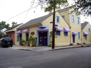
The business that occupies the building is called the Carrollton Flower Market and its at the corner of Dublin and Burthe.
Burma Jones likes to hang out at the bar of Mattie’s Ramble Inn, which was a bar and grocery store in the Carrollton neighborhood. It was here that Burma got the idea of sabotaging Lana Lee from an older, wiser patron. Carrollton is west of the French Quarter and the Garden District. If you follow St. Charles Ave. all the way to the River, you’ll hit Carrollton.
It was incorporated as a city in 1833 and annexed by New Orleans in 1874.
Toole said that Mattie’s Ramble Inn sat on a corner, and there are a lot of corner businesses in Carrollton. I found this building, sitting on a corner, that looks like it could be Mattie’s…
The business that occupies the building is called the Carrollton Flower Market and its at the corner of Dublin and Burthe.
Paradise Vendors
Paradise Vendors
After Ignatius’ failed venture at Levy Pants, he wanders into Paradise Vendors, following his nose into their kitchen. Paradise Vendors is a hot dog vending company that is obviously a parody of the ubiquitous Lucky Dog.
Here is a Lucky Dog cart, on which the Paradise cart was modeled…
After Ignatius’ failed venture at Levy Pants, he wanders into Paradise Vendors, following his nose into their kitchen. Paradise Vendors is a hot dog vending company that is obviously a parody of the ubiquitous Lucky Dog.
Here is a Lucky Dog cart, on which the Paradise cart was modeled…

Ignatius ends up pushing a hot dog cart through various parts of New Orleans (mostly through the French Quarter), trying to get people to buy hot dogs. On most days, he eats as many as he sells and he rarely returns a profit.
Toole said that Paradise Vendors was located in a commercial building on Poydras St. and it was formerly an auto body repair shop. That would make sense because the building also has garage doors.
On the first day Ignatius took the cart, he promised Mr. Clyde to push it for one hour. He left Paradise Vendors, turned the corner, and parked the cart against a building. There, he prepared himself a hot dog, and ate it. At that moment, George was “wandering up Carondelet” and he tried to buy a hot dog from Ignatius. They got into a little scuffle because Ignatius refused to sell him one. After George left, Ignatius ate another hot dog to ease his frustrations.
Ignatius then continued up Carondelet St., and he turned at the next corner, which is Lafayette Street. He “stopped by the worn granite walls of Gallier Hall to consume two more of the Paradise hot dogs before continuing on the last leg of his journey.” Toole writes that Ignatius “turned the final corner and saw again the PARADISE VENDORS, INC., sign hanging out over the sidewalk of Poydras Street at angle.” That means that he must have turned on St. Charles St. and headed back to Poydras.
What you have there is a one-block circuit going from Poydras, to Carondelet, to Lafayette, to St. Charles, and back to Poydras. The streets are still there, and Gallier Hall is still there, but there are no buildings on Poydras that match Toole’s description. The building that actually sits there today is the Federal Reserve Bank of Atlanta’s New Orleans branch.
Here’s a view of the Bank and its parking lot from Poydras Street…

That’s actually sort of a “side shot” because the front of the Federal Reserve Bank is on St. Charles. In that photo, you’re seeing more of the parking lot and the side of the Bank building.
Here’s a photo of the corner of Poydras Street and Carondelet St…
Here’s a photo of the corner of Poydras Street and Carondelet St…

Here’s a photo of Carondelet St., showing the direction Ignatius would have traveled…
Here are a couple photos of Gallier Hall, and one of Lafayette Square, which is just across St. Charles Ave…

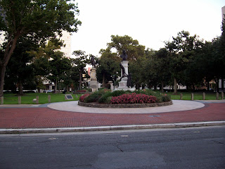
Gallier Hall was dedicated in 1853 and was the City Hall for over a century. It is now a reception hall and convention center. It also holds The Ty Tracy Theater.
Now, back to Paradise Vendors…
The exact place where the building should be now houses the Federal Reserve Bank. Groundbreaking for that building took place in 1963 and the building was completed in 1966. On the spot where the Bank building actually sits used to be the Howard annex to City Hall, but I cannot find any reference to the Poydras Street part of the property. Once again, this supports my theory that Confederacy was set in 1962. If Paradise Vendors was actually at that specific location, it would have been demolished to make way for the Federal Reserve Bank and its parking lot.
Here’s a link to the Federal Reserve Bank’s website…
http://www.frbatlanta.org/invoke.cfm?objectid=A3535EDB-1354-11D5-93310020352A7A95&method=display
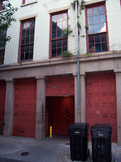
Incidentally, Lucky Dogs’ headquarters is located at 517 Gravier St., which is only a few blocks away. Their building looks like this…
Now, back to Paradise Vendors…
The exact place where the building should be now houses the Federal Reserve Bank. Groundbreaking for that building took place in 1963 and the building was completed in 1966. On the spot where the Bank building actually sits used to be the Howard annex to City Hall, but I cannot find any reference to the Poydras Street part of the property. Once again, this supports my theory that Confederacy was set in 1962. If Paradise Vendors was actually at that specific location, it would have been demolished to make way for the Federal Reserve Bank and its parking lot.
Here’s a link to the Federal Reserve Bank’s website…
http://www.frbatlanta.org/invoke.cfm?objectid=A3535EDB-1354-11D5-93310020352A7A95&method=display
Incidentally, Lucky Dogs’ headquarters is located at 517 Gravier St., which is only a few blocks away. Their building looks like this…
Subscribe to:
Posts (Atom)