Thursday, January 1, 2009

Tulane University

Tulane University
Ignatius went to Tulane University and then “stuck around there for four more years to get him a master’s degree.” Mrs. Reilly is very proud to tell people that her son “graduated smart.”
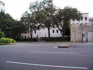
Tulane University was founded in 1834 as a medical school. It expanded and its current campus opened in 1894. The campus sits on St. Charles Avenue and is flanked by many beautiful, and huge live oaks.
Here’s a photo of the main building…

Ignatius loves to tell the story of how he took a Scenicruiser bus to Baton Rouge to take a job in the “Medieval Culture Department” at an un-named university. There are a number of small colleges in and around Baton Rouge, but Toole was probably referencing Louisiana State University.

Prytania

Prytania
Ignatius was apparently a frequent customer of the Prytania movie house, because the staff talks derisively of him being there “again.” The Prytania is a wonderful example of how theaters once looked. They were elegant and cozy and two screens were more than enough for the neighborhood.
The Prytania opened in 1915 as a single-screen theater and today it is the only one in Louisiana. It recently underwent a major renovation that added a new lobby and a huge screen.
Here’s the Prytania’s website with a couple of old photos, showing how it probably looked when Ignatius critiqued their films.
http://www.theprytania.com/
The Prytania is still open at 5339 Prytania St. and its not far from the Reilly House on Constantinople St.
Here are a couple of photos of the exterior as it looked in August 2008…

Here are a few photos of the interior. In the first picture, you can see the counter where Ignatius would have purchased his Milky Way bars, popcorn, and soda…

When I was there, they were showing “Tropic Thunder”…

In Toole’s description of the movie Ignatius watched and hated, we can get an idea of the time in which the book was set. Its pretty obvious that it was set in the early 1960’s, but by looking at several clues we can narrow it down even further. For example, the movie was a musical which was set in a circus. There were trapeze acts, a sideshow, and an elephant. The movie was distributed by MGM, because Ignatius listened as “the lion roared,” just before the title screen.
That all perfectly describes “Billy Rose’s Jumbo,” which starred Doris Day and Jimmy Durante. It was released in the United States on December 6, 1962. This matches up with other references in the book that I’ll discuss as we get to them. The winter release also matches up with Toole’s passage concerning Patrolman Mancuso riding the motorcycle on St. Charles Avenue through the “mild winter sun.”
I think its fair to say that A Confederacy of Dunces was set in the winter of 1962 - 1963.

Levy Pants, Inc.

Levy Pants
At his mother’s insistence, Ignatius answered a classified ad in the newspaper and began working for Levy Pants, Inc. The ad told prospective employees to “Apply Levy Pants, Industrial Canal and River,” which places the building at the eastern border of the Bywater neighborhood.
Bywater is part of the Ninth Ward, and more specifically, the Upper Ninth Ward. The Upper Ninth Ward is “upriver” from the Lower Ninth Ward and both sit just east of the French Quarter.
Here’s a Google Map’s view of Bywater, and coincidentally, the “stick-pin” is probably pretty close to where Levy Pants would have been…
http://maps.google.com/maps?hl=en&q=bywater%2C%20new%20orleans&um=1&ie=UTF-8&sa=N&tab=wl

Ignatius entered and took in the building, and Toole describes it as such:
“Through the dusty windows of the office there was a gray view of the Poland Avenue wharf, the Army Terminal, the Mississippi, and, far in the distance, the dry docks and the roofs of Algiers across the river.” From this vantage point, Ignatius is looking towards the southeast.
Later, as Ignatius heads home, the taxi takes St. Claude Ave., which is one of the main roads through that part of New Orleans. It roughly parallels the River and would easily take him back to his own neighborhood and Constantinople St.
Toole described the building in more detail in another passage:
“Levy Pants was two structures fused into one macabre unit. The front of the plant was a brick commercial building of the nineteenth century with a mansard roof that bulged out into several rococo dormer windows, the panes of which were mostly cracked. Within this section the office occupied the third floor, a storage area the second, and refuse the first. Attached to this building, which Mr. Gonzalez referred to as ‘the brain center,’ was the factory, a barnlike prototype of an airplane hangar. The two smokestacks that rose from the factory’s tin roof leaned apart at an angle that formed an outsized rabbit-eared television antenna…”
He went on to say:
“Alongside the neat gray wharf sheds that lined the river and canal across the railroad tracks, Levy Pants huddled, a silent and smoky plea for urban renewal.”
Those are all very descriptive and clearly place the building in Bywater, near the river, and near the Industrial Canal. I’ve been all through this area and I cannot find a building that looks like the one Toole is describing.
Most of the wharfs are gone, but its easy to tell where they once were. They were usually named for the street that dead-ends into the river, and Poland Ave. does exactly that. The Poland Avenue wharf is one of the few still standing on this stretch of the Mississippi River and it sits right next to the Naval Support Activity.
Here is another indication of the time in which Confederacy is set.
In 1919, the US Army constructed several buildings on the site for use as a general depot during WWI. The base continued operations through WWII and, in 1955, became known as the New Orleans Army Terminal. The base changed its name to the New Orleans Army Base in 1965, and then was handed over to the US Navy in 1966. At that time, it became part of the Naval Support Activity, which already had a presence on the opposite side of the River.
If Toole is calling this site the Army Terminal, Confederacy must take place after 1955 but before 1965.
OK, back to the location of Levy Pants…
Here are a couple of photos of the NSA from Poland Ave. The first is from the southernmost part of Poland where it meets Chartres St. The second is a little farther north and it shows a ship docked at the Poland Ave. wharf…

Based on Toole’s description, we’re looking for a three-story building at Industrial Canal and the River, which has a view of the Army Terminal, the Poland Street wharf, and Algiers.
Like I said, I’ve been all through Bywater but I can’t find a building that looks like Toole described. However, I did find this building at the corner of Pauline and Dauphine that roughly fits Toole’s description.
Its currently being used as the Bywater Church of Christ.

I know what you’re thinking…The building is only two stories, not three. There is no mansard roof. There are no rococo dormer windows. There’s only one smokestack. I know.
However, it is “two structures fused into one … unit.” I’ll let you decide if its macabre. The “factory” part of the building looks like a hangar and there are a bunch of cracked and shattered windows.
If Confederacy was really set in 1962, then there could have been many demolitions and new constructions in between then and now. Or, it could have been completely fictional from the beginning.
On a completely different note, Bywater was one of the hardest hit areas when Hurricane Katrina roared through New Orleans. The Industrial Canal suffered two major breaches and flooded parts of the neighborhood with up to ten feet of water. Here is a photo of a home near the intersection of Pauline and Dauphine at 3805 Dauphine Ave.
In the close-up, you can see the spray painted symbol that has become ubiquitous with Katrina search and rescue operations. The “X” actually starts off as a slash from upper-right-to-lower-left. The team doing the search puts the date (and usually the time) at the top. In this case it’s 9-6, or September 6, 2005. They also put their team name. In the completed “X,” it’ll be to the left. Many search and rescue teams came from all over the country to aid New Orleans in the post-hurricane efforts. In this case it’s Texas Task Force 1.
When the search team leaves the location, they put the upper-left-to-lower-right slash which completes the “X” and they add the other information. To the right of the “X” you’ll find possible hazards, such as gas leaks, rats, or unstable walls. I’m not sure what “NE” means. At the bottom of the “X” they put the number of dead inside the location. In this case they found no one.
The reason they do the “half X” going in, and the “half X” going out is so that anyone coming to the house will know if it has been searched, is in the process of being searched, or has not yet been searched. Also, if you see a “half X” with yesterday’s date on it, the search team may be trapped inside.
The Times-Picayune website has a very good interactive graphic that explains how and why New Orleans flooded. Check it out here…
http://www.nola.com/katrina/graphics/flashflood.swf
Here’s another graphic showing the extent and depth of the flooding…
Katrina Flood Depth

Bowling Alley

Bowling Alley
Santa Bataglia and Mrs. Reilly went bowling a couple of times throughout the book, and at one point, Mrs. Reilly calls the bowling alley by name. She calls it Fazzio’s, which is a bowling alley in Harvey, LA. That’s on the opposite side of the Mississippi River and wouldn’t be the place Mr. Reilly was talking about.
There used to be a Fazzio’s on North Rampart St., but I’m not sure exactly where it was located. There are many buildings that could have housed it, but there isn’t one there today.

3/10/09 Edit: Thanks for the info Sedna1000! I really appreciate it. I found this photo that matches up with yours rather nicely...

http://louisdl.louislibraries.org/cdm4/item_viewer.php?CISOROOT=/CLF&CISOPTR=776&CISOBOX=1&REC=2

The Levy Home

The Levy Home
The Levy home overlooked the waters of Bay St. Louis. I don’t have a picture of Bay St. Louis, but here’s a Google Map’s link to it…
http://maps.google.com/maps?ie=UTF-8&hl=en&tab=wl

Mattie's Ramble Inn

Mattie’s Ramble Inn
Burma Jones likes to hang out at the bar of Mattie’s Ramble Inn, which was a bar and grocery store in the Carrollton neighborhood. It was here that Burma got the idea of sabotaging Lana Lee from an older, wiser patron. Carrollton is west of the French Quarter and the Garden District. If you follow St. Charles Ave. all the way to the River, you’ll hit Carrollton.
It was incorporated as a city in 1833 and annexed by New Orleans in 1874.
Toole said that Mattie’s Ramble Inn sat on a corner, and there are a lot of corner businesses in Carrollton. I found this building, sitting on a corner, that looks like it could be Mattie’s…

The business that occupies the building is called the Carrollton Flower Market and its at the corner of Dublin and Burthe.

Paradise Vendors

Paradise Vendors
After Ignatius’ failed venture at Levy Pants, he wanders into Paradise Vendors, following his nose into their kitchen. Paradise Vendors is a hot dog vending company that is obviously a parody of the ubiquitous Lucky Dog.
Here is a Lucky Dog cart, on which the Paradise cart was modeled…

Ignatius ends up pushing a hot dog cart through various parts of New Orleans (mostly through the French Quarter), trying to get people to buy hot dogs. On most days, he eats as many as he sells and he rarely returns a profit.
Toole said that Paradise Vendors was located in a commercial building on Poydras St. and it was formerly an auto body repair shop. That would make sense because the building also has garage doors.
On the first day Ignatius took the cart, he promised Mr. Clyde to push it for one hour. He left Paradise Vendors, turned the corner, and parked the cart against a building. There, he prepared himself a hot dog, and ate it. At that moment, George was “wandering up Carondelet” and he tried to buy a hot dog from Ignatius. They got into a little scuffle because Ignatius refused to sell him one. After George left, Ignatius ate another hot dog to ease his frustrations.
Ignatius then continued up Carondelet St., and he turned at the next corner, which is Lafayette Street. He “stopped by the worn granite walls of Gallier Hall to consume two more of the Paradise hot dogs before continuing on the last leg of his journey.” Toole writes that Ignatius “turned the final corner and saw again the PARADISE VENDORS, INC., sign hanging out over the sidewalk of Poydras Street at angle.” That means that he must have turned on St. Charles St. and headed back to Poydras.
What you have there is a one-block circuit going from Poydras, to Carondelet, to Lafayette, to St. Charles, and back to Poydras. The streets are still there, and Gallier Hall is still there, but there are no buildings on Poydras that match Toole’s description. The building that actually sits there today is the Federal Reserve Bank of Atlanta’s New Orleans branch.
Here’s a view of the Bank and its parking lot from Poydras Street…

That’s actually sort of a “side shot” because the front of the Federal Reserve Bank is on St. Charles. In that photo, you’re seeing more of the parking lot and the side of the Bank building.
Here’s a photo of the corner of Poydras Street and Carondelet St…


Here’s a photo of Carondelet St., showing the direction Ignatius would have traveled…

Here are a couple photos of Gallier Hall, and one of Lafayette Square, which is just across St. Charles Ave…

Gallier Hall was dedicated in 1853 and was the City Hall for over a century. It is now a reception hall and convention center. It also holds The Ty Tracy Theater.
Now, back to Paradise Vendors…
The exact place where the building should be now houses the Federal Reserve Bank. Groundbreaking for that building took place in 1963 and the building was completed in 1966. On the spot where the Bank building actually sits used to be the Howard annex to City Hall, but I cannot find any reference to the Poydras Street part of the property. Once again, this supports my theory that Confederacy was set in 1962. If Paradise Vendors was actually at that specific location, it would have been demolished to make way for the Federal Reserve Bank and its parking lot.
Here’s a link to the Federal Reserve Bank’s website…
http://www.frbatlanta.org/invoke.cfm?objectid=A3535EDB-1354-11D5-93310020352A7A95&method=display
Incidentally, Lucky Dogs’ headquarters is located at 517 Gravier St., which is only a few blocks away. Their building looks like this…